- ✓🚀 Updated for 2026: Aligned with the latest CBSE Class 12 Boards, CUET UG, UPSC CSE, NDA, and State PSCs syllabus.
- ✓🧠 Output & Concept Based: Covers basics to advanced scenarios.
- ✓📊 Live Gamification: Track your score and time dynamically.
- ✓📥 Buy PDF: Available instantly via our Telegram channel.
Test Blueprint & Topic Weightage
| Section / Topic | Question Range | Difficulty Level |
|---|---|---|
| Urban Planning & Civic Architecture | Q1 – Q5, Q16 – Q20 | Easy to Medium |
| Subsistence, Agriculture & Animal Hubandry | Q6 – Q10 | Medium |
| Craft Production & Maritime Trade Networks | Q11 – Q15, Q21 – Q30 | Hard |
| Society, Religion & Burial Practices | Q31 – Q40 | Medium to Hard |
| Archaeological Discovery & Civilization Decline | Q41 – Q50 | Medium to Hard |
Practice bricks beads and bones mcq (Live Mock Test)
⏱️ Estimated Time: Minutes | 🎯 Target Score: 40+ | 📊 Difficulty: Moderate to Hard
Bricks Beads and Bones MCQ – 50 Most Expected Questions
Supercharge Your Preparation
Join our Telegram to practice more MCQs and guarantee your selection.
📱 Join Telegram💬 Community Doubts
High-Yield Core Concepts
Semantic Comparison: Harappan Civilization vs Mesopotamian Civilization
| Feature / Metric | Harappan Civilization | Mesopotamian Civilization |
|---|---|---|
| Core Definition | Highly standardized, egalitarian urban centers in the Indus Valley. | City-states centered around monumental royal and religious architecture. |
| Primary Use Case | Focus on public sanitation, uniform weights, and standardized grid streets. | Focus on massive Ziggurats, royal tombs, and complex cuneiform archives. |
| Exam Importance | Tests knowledge of town planning, trade seals, and environmental decline. | Tests comparative knowledge of ancient trade networks (Meluhha vs Magan). |
Why are Indus Valley Civilization questions critical for my exams?
Is this the best Class 12 History Chapter 1 mock test available?
Will these help with CUET History objective questions?
Multiple Choice Questions
Question 1: Consider the following statements regarding the Town Layout and Brick Standardization in Mohenjodaro: 1. The settlement was primarily divided into two sections, with the Citadel being smaller but higher, and the Lower Town being larger but lower. 2. The Citadel owed its height to the fact that its buildings were constructed on mud-brick platforms. 3. The baked bricks used across Harappan settlements had a standardized ratio where the length and breadth were four times and twice the height, respectively. Which of the above statements is/are correct?
- Only 1 and 2
- Only 2 and 3
- Only 1 and 3
- 1, 2, and 3 (Correct Answer)
Explanation
Direct Answer: Option D is the correct answer, as all three statements are factually accurate regarding the urban layout of Mohenjodaro.Concept Definition: Mohenjodaro was one of the largest and most well-planned urban centers of the Harappan civilization, characterized by its systematic structural division and standardized construction materials.Structural Breakdown: The city was physically separated into two main parts.The Citadel was built on elevated mud-brick platforms and contained special public structures.The Lower Town was much larger, situated at a lower elevation, and served as the primary residential area.Both sections were surrounded by walls.Historical/Related Context: Alexander Cunningham, the first Director-General of the Archaeological Survey of India, noted the massive scale of brick-making when observing that stolen bricks from Harappa were enough to lay 100 miles of railway line.The Harappans maintained strict uniformity in their building materials across the civilization.Causal Reasoning: The standardization of bricks (ratio of 4:2:1 for length:breadth:height) and the deliberate elevation of the Citadel demonstrate a highly centralized planning authority capable of mobilizing labor on a massive scale before implementing construction.
Question 2: Consider the following statements regarding the Domestic Architecture and Privacy features of residential buildings in Mohenjodaro: 1. Residential buildings were typically centered on a courtyard, which served as the primary space for activities such as cooking and weaving. 2. To ensure proper ventilation, numerous large windows were situated in the walls along the ground level of the houses. 3. The main entrance was deliberately designed so that it did not provide a direct, unobstructed view of the interior courtyard. Which of the above statements is/are correct?
- Only 1 and 2
- Only 1 and 3 (Correct Answer)
- Only 2 and 3
- 1, 2, and 3
Explanation
Direct Answer: Option B is correct because statement 2 is factually incorrect.Concept Definition: Domestic architecture in the Lower Town of Mohenjodaro reflects a highly advanced understanding of residential planning, focusing heavily on central community spaces and strict household privacy.Structural Breakdown: The typical Harappan house featured a central courtyard surrounded by rooms on all sides.Every house had its own bathroom paved with bricks, and many featured staircases leading to a second storey or flat roof.Historical/Related Context: Excavations at Mohenjodaro have revealed that residential planning remained consistent throughout the mature phase of the civilization.The courtyard was especially vital during the hot and dry seasons for domestic activities.Causal Reasoning: The Harappans demonstrated an apparent concern for privacy.Because of this, they intentionally omitted windows from the walls along the ground level, and positioned the main entrance in a way that blocked any direct line of sight into the interior courtyard from the street.
Question 3: Consider the following statements regarding the Urban Drainage System and Street Alignment in Mohenjodaro: 1. The roads and streets in the Lower Town were laid out along an approximate grid pattern, intersecting at right angles. 2. Archaeological evidence indicates that residential houses were built first, and subsequently, the streets and drains were laid out around them to fit the available space. 3. Every residential house needed to have at least one wall adjacent to a street to allow domestic wastewater to flow into the main street drains. Which of the above statements is/are correct?
- Only 1
- Only 1 and 3 (Correct Answer)
- Only 2 and 3
- 1, 2, and 3
Explanation
Direct Answer: Option B is correct because statement 2 incorrectly reverses the chronological order of town planning.Concept Definition: The carefully planned drainage system of the Harappan cities is considered one of the most distinctive features of their urban planning, described by early archaeologists as the most complete ancient system discovered.Structural Breakdown: The municipal layout followed a strict grid pattern.The main drainage channels were constructed using bricks set in mortar, covered with loose bricks or limestone that could be removed for cleaning, and equipped with sumps or cesspits at intervals.Historical/Related Context: This sophisticated level of civic engineering was not limited to large cities like Mohenjodaro; smaller settlements like Lothal also featured advanced drainage, where houses were built of mud bricks but drains were specifically constructed using durable burnt bricks.Causal Reasoning: The settlement was planned before implementation.Streets and street drains were explicitly laid out first, and only then were houses constructed along them.This prerequisite ensured that every house could position at least one wall along the street, allowing domestic wastewater to efficiently gravity-flow into the public drainage network.
Question 4: Consider the following statements regarding the Great Bath of Mohenjodaro: 1. The Great Bath was a large rectangular tank situated within the Lower Town, primarily utilized for daily domestic washing by the general populace. 2. The tank was made entirely watertight by setting bricks on their edges and utilizing a thick layer of bitumen and a mortar of gypsum. 3. The structure featured two flights of steps, located on the north and south sides, leading directly down into the tank. Which of the above statements is/are correct?
- Only 1 and 2
- Only 2 and 3 (Correct Answer)
- Only 1 and 3
- 1, 2, and 3
Explanation
Direct Answer: Option B is correct because statement 1 misidentifies both the location and the purpose of the Great Bath.Concept Definition: The Great Bath was a massive public water structure located on the elevated Citadel of Mohenjodaro, largely believed by scholars to have been designed for special ritual or religious bathing rather than everyday use.Structural Breakdown: The rectangular tank was situated in a courtyard and surrounded by a corridor on all four sides.It included rooms on three sides, one containing a large well that supplied the water.An outlet from one corner led to a huge drain.Historical/Related Context: The Great Bath represents one of the earliest examples of waterproofing in the ancient world.Across a lane to the north, archaeologists also discovered a smaller building containing exactly eight bathrooms, with drains connecting to a central corridor drain.Causal Reasoning: The exclusive location of the Great Bath on the fortified Citadel, combined with its elaborate waterproof construction and adjacent specialized bathrooms, strongly suggests that it was restricted to the elite or priestly class for ceremonial purification purposes.
Question 5: Consider the following statements regarding the specific variations in Harappan Citadels and urban amenities: 1. While the Citadel at Mohenjodaro was physically walled off from the Lower Town, the Citadel within the settlement of Lothal was built at a height but was not walled off. 2. Scholars and archaeologists have estimated that the total number of domestic and public wells in the city of Mohenjodaro was approximately 700. 3. In smaller settlements such as Dholavira and Lothal, the entire settlement was fortified, and sections within the town were also separated by walls. Which of the above statements is/are correct?
- Only 1 and 2
- Only 2 and 3
- Only 1 and 3
- 1, 2, and 3 (Correct Answer)
Explanation
Direct Answer: Option D is correct as all three statements accurately describe the variations and specific structural details of Harappan urban amenities.Concept Definition: While Mohenjodaro serves as the standard template for Harappan urban planning, regional variations existed in settlement fortification, and extensive hydraulic engineering was a common denominator across the civilization.Structural Breakdown: The typical Harappan model involves a strict wall separation between the high Citadel and the Lower Town.However, sites like Dholavira featured massive overall fortifications with internal walled subdivisions, whereas Lothal’s Citadel lacked an internal wall but maintained its elevated status.Historical/Related Context: The mastery of water management was a defining trait of the Harappans.In Mohenjodaro alone, the sinking of roughly 700 wells meant that almost every neighborhood had reliable access to groundwater.Many of these wells were placed in outer rooms reachable from the street for use by passers-by.Causal Reasoning: The architectural variations across different Harappan sites were largely adaptations to local topographies and regional security needs.Meanwhile, the staggering number of wells in Mohenjodaro reflects the civilization’s acute prioritization of sanitation, hygiene, and public water accessibility in a semi-arid environment.
Question 6: Consider the following statements regarding the dietary practices and archaeo-botanical evidence of the Harappan civilization: 1. The Harappans consumed a wide range of plant and animal products, with finds of wheat, barley, lentil, chickpea, and sesame being common at mature Harappan sites. 2. Finds of rice are relatively rare compared to other grains, while millets have been found specifically from sites in Gujarat. 3. The dietary practices of the Harappans are reconstructed by archaeo-zoologists who specialize in the study of ancient plant remains. Which of the above statements is/are correct?
- Only 1 and 2 (Correct Answer)
- Only 2 and 3
- Only 1 and 3
- 1, 2, and 3
Explanation
Direct Answer: Option A is the correct answer because statement 3 is factually incorrect.Concept Definition: Subsistence strategies of the Harappan civilization involved a mixed diet of agricultural crops and animal products, which are studied through the analysis of charred grains and seeds.Structural Breakdown: The agricultural dietary base consisted heavily of winter crops like wheat and barley, alongside legumes such as lentil and chickpea.Millets formed a crucial part of the diet in the Gujarat region, whereas rice cultivation was evidently much less prominent.Historical/Related Context: The reconstruction of ancient dietary habits is highly specialized.Archaeo-botanists are the experts who study ancient plant remains, whereas archaeo-zoologists (or zooarchaeologists) are the specialists who analyze animal bones.Causal Reasoning: The rarity of rice finds suggests that the semi-arid climate and the specific water management techniques of the core Harappan regions were better suited for hardy crops like wheat, barley, and millets rather than water-intensive rice cultivation.
Question 7: Consider the following statements regarding animal domestication and wildlife interaction in the Harappan civilization: 1. Bones of cattle, sheep, goat, buffalo, and pig found at Harappan sites indicate that these animals were domesticated by the population. 2. Evidence from archaeo-zoologists confirms that Harappans strictly avoided consuming meat from wild animal species such as boar, deer, and gharial. 3. While bones of wild species are found at the sites, it remains unclear whether the Harappans hunted these animals themselves or obtained meat from other hunting communities. Which of the above statements is/are correct?
- Only 1 and 2
- Only 1 and 3 (Correct Answer)
- Only 2 and 3
- 1, 2, and 3
Explanation
Direct Answer: Option B is correct because statement 2 is factually incorrect regarding the consumption and presence of wild animal species.Concept Definition: Animal husbandry was a core component of the Harappan subsistence strategy, running parallel to their agricultural practices, and was supplemented by the exploitation of wild fauna.Structural Breakdown: The faunal assemblage at Harappan sites is divided into domesticated species (cattle, sheep, goats, buffalo, pigs) used for food, dairy, and draught purposes, and wild species (boar, deer, gharial) whose bones are also consistently found in the occupational debris.Historical/Related Context: Studies by archaeo-zoologists confirm that Harappans definitely consumed meat from wild species, contradicting any assumption of a strictly domesticated meat diet.Bones of fish and fowl have also been recovered extensively.Causal Reasoning: Despite the clear presence of wild animal bones, archaeologists cannot definitively establish the procurement method.The Harappans may have engaged in hunting expeditions themselves, or, more likely given their advanced trade networks, they bartered agricultural surplus for meat provided by specialized hunter-gatherer communities living on the periphery of their settlements.
Question 8: Consider the following statements regarding the agricultural technologies and field ploughing practices of the Harappans: 1. Terracotta models of the plough have been discovered at archaeological sites in Cholistan and at Banawali in Haryana. 2. The ploughed field discovered at Kalibangan in Rajasthan showed a single, uniform set of furrows, indicating the cultivation of only one crop at a time. 3. The widespread discovery of terracotta bulls and their depictions on seals suggest that the bull was known, leading archaeologists to extrapolate that oxen were used for ploughing. Which of the above statements is/are correct?
- Only 1 and 2
- Only 2 and 3
- Only 1 and 3 (Correct Answer)
- 1, 2, and 3
Explanation
Direct Answer: Option C is correct because statement 2 inaccurately describes the structural layout of the ploughed field found at Kalibangan.Concept Definition: Harappan agricultural technology relied on animal-drawn implements and advanced cropping patterns to maximize yield in varying environmental conditions.Structural Breakdown: The primary evidence for traction agriculture comes from terracotta plough models found in Banawali and Cholistan.Furthermore, the actual ploughed field excavated at Kalibangan (Early Harappan level) revealed two distinct sets of furrows intersecting at right angles.Historical/Related Context: The right-angle furrow pattern is a highly sophisticated agricultural technique that is still used in some parts of modern India to grow two different crops simultaneously in the same field, thereby optimizing space and seasonal rainfall.Causal Reasoning: Because wooden ploughshares decompose over millennia, archaeologists must rely on indirect evidence like terracotta models and seal depictions of bulls.The combination of these artifacts provides a strong, logical basis to conclude that oxen-drawn ploughs were the standard mechanism for tilling the soil across the civilization.
Question 9: Consider the following statements regarding the irrigation systems and water management for Harappan agriculture: 1. Archaeological traces of canals have been found at the Harappan site of Shortughai in Afghanistan. 2. Similar extensive canal networks have been well-preserved and heavily documented across the plains of Punjab and Sind. 3. Water reservoirs discovered at Dholavira in Gujarat may have been used to store water specifically to sustain agriculture. Which of the above statements is/are correct?
- Only 1 and 2
- Only 1 and 3 (Correct Answer)
- Only 2 and 3
- 1, 2, and 3
Explanation
Direct Answer: Option B is correct because statement 2 is factually incorrect regarding the preservation of canals in Punjab and Sind.Concept Definition: Harappan agriculture was predominantly located in semi-arid regions, necessitating the development of artificial irrigation infrastructure such as canals, wells, and reservoirs to ensure crop viability.Structural Breakdown: Clear evidence of canal irrigation exists at Shortughai (Afghanistan). In Dholavira (Gujarat), massive rock-cut reservoirs were constructed to harvest and store monsoon runoff.Additionally, water drawn from domestic and public wells was frequently used for localized irrigation.Historical/Related Context: While Shortughai provides concrete proof of canal engineering, archaeologists have not found similar surviving canal traces in the core regions of Punjab and Sind.Causal Reasoning: The absence of canal traces in Punjab and Sind is not necessarily proof that they never existed.It is highly probable that ancient canals in these major river floodplains were completely silted up or washed away by millennia of recurring floods and shifting river courses, unlike the more isolated and preserved remnants in Afghanistan.
Question 10: Consider the following statements regarding food processing implements and saddle querns in the Harappan civilization: 1. Saddle querns were the only means of grinding cereals found at Mohenjodaro, typically made of hard, gritty, igneous rock or sandstone. 2. Excavations reveal two main types of saddle querns: one on which a smaller stone was pushed to and fro, and another used for pounding herbs and spices with a base stone. 3. Early archaeologists, such as Ernest Mackay, completely ignored these everyday utilitarian objects, focusing their reports entirely on luxury gold and silver artifacts. Which of the above statements is/are correct?
- Only 1 and 2 (Correct Answer)
- Only 2 and 3
- Only 1 and 3
- 1, 2, and 3
Explanation
Direct Answer: Option A is the correct answer because statement 3 is factually inaccurate regarding the focus of early archaeologists like Ernest Mackay.Concept Definition: Food processing in Harappan households required heavy-duty stone implements to mill hard grains into flour and to crush herbs, with the saddle quern being the primary tool for this purpose.Structural Breakdown: Saddle querns are characterized by a roughly convex base, usually set in the earth to prevent rocking.The first type operated with a smaller rolling/pushing stone strictly for cereals.The second type featured a deep central depression from the heavy pounding of a second stone, primarily used for curries and spices.Historical/Related Context: Contrary to the claim in statement 3, Ernest Mackay detailed these specific domestic implements extensively in his 1937 publication “Further Excavations at Mohenjodaro,” recognizing their vital role in reconstructing the daily lives of the common people.Causal Reasoning: The reliance on hard, gritty igneous rock or sandstone for these querns was a deliberate material choice.The rough texture was necessary to create enough friction to effectively break down tough cereal grains and fibrous herbs, demonstrating a practical understanding of material utility in domestic engineering.
Question 11: Consider the following statements regarding the settlement of Chanhudaro and Harappan craft production: 1. Compared to the massive 125-hectare layout of Mohenjodaro, Chanhudaro was a tiny settlement of approximately 7 hectares almost exclusively devoted to craft production. 2. The craft activities at Chanhudaro were diverse, encompassing bead-making, shell-cutting, metal-working, seal-making, and weight-making. 3. The materials used to manufacture beads were highly diverse, incorporating stones like carnelian, metals like gold, and artificially produced materials like faience. Which of the above statements is/are correct?
- Only 1 and 2
- Only 2 and 3
- Only 1 and 3
- 1, 2, and 3 (Correct Answer)
Explanation
Direct Answer: Option D is the correct answer, as all three statements accurately describe the scale and scope of craft production at Chanhudaro.Concept Definition: Craft production was a major economic driver in the Harappan civilization, with certain settlements acting as specialized industrial hubs rather than massive residential centers.Structural Breakdown: Chanhudaro was tiny (7 hectares) compared to Mohenjodaro (125 hectares). Despite its size, it dominated the manufacturing of utilitarian and luxury goods.Artisans utilized a wide spectrum of materials including stones (carnelian, jasper, steatite), metals (copper, bronze, gold), and synthetic materials (faience, terracotta). Historical/Related Context: Archaeologists identify these ancient centers of craft production by looking for raw materials, unfinished objects, and specifically, rejected waste materials.Waste is one of the best archaeological indicators, as smaller pieces of stone or shell chipped off during manufacturing were left behind at the exact site of production.Causal Reasoning: The centralization of specialized craft production in smaller settlements like Chanhudaro allowed the civilization to efficiently process raw materials before exporting the finished luxury goods to larger administrative centers like Harappa and Mohenjodaro.
Question 12: Consider the following statements regarding the techniques of bead-making and material processing in the Harappan civilization: 1. Steatite, being an exceptionally hard and brittle stone, was extremely difficult to carve and was therefore rarely utilized by Harappan bead makers. 2. Some beads were molded out of a paste made with steatite powder, which permitted the creation of various complex shapes unlike harder geometric stones. 3. The distinctive red colour of carnelian was obtained by firing the yellowish raw material and the beads themselves at various stages of production. Which of the above statements is/are correct?
- Only 1 and 2
- Only 2 and 3 (Correct Answer)
- Only 1 and 3
- 1, 2, and 3
Explanation
Direct Answer: Option B is the correct answer because statement 1 is factually incorrect regarding the physical properties of steatite.Concept Definition: Harappan artisans employed highly advanced and varied techniques to manufacture beads, tailoring their methods specifically to the physical properties of the stone or metal being used.Structural Breakdown: Carnelian, a beautiful red stone, was processed through a complex heating technique.The raw nodule was yellowish; artisans fired it, chipped it into rough shapes, precisely flaked it, and finally polished and drilled it.Steatite paste was used for micro-beads and complex molds.Historical/Related Context: Specialized drills used in these advanced manufacturing processes have been excavated at Chanhudaro, Lothal, and more recently at Dholavira, indicating that the technology was standardized and shared across different regional craft centers.Causal Reasoning: Statement 1 is false because steatite is actually a very soft stone, not a hard one.Its softness is precisely what made it the most widely used material in Harappan craft, as it could easily be carved, ground into powder, and mixed into a paste to mold into shapes that were impossible to achieve with harder stones like agate or jasper.
Question 13: Consider the following statements regarding the specialized procurement centers of Nageshwar and Balakot: 1. Nageshwar and Balakot were specialized craft centers located deep inland, established strategically near major agricultural hubs to feed the artisan population. 2. These two settlements were dedicated exclusively to the manufacture of shell objects, such as bangles, ladles, and intricate inlay work. 3. Finished shell products from these specialized coastal centers were systematically transported to larger urban centers like Mohenjodaro and Harappa. Which of the above statements is/are correct?
- Only 1 and 2
- Only 2 and 3 (Correct Answer)
- Only 1 and 3
- 1, 2, and 3
Explanation
Direct Answer: Option B is the correct answer because statement 1 misidentifies the geographical location of Nageshwar and Balakot.Concept Definition: To maintain a steady supply of raw materials for craft production, the Harappans adopted a logistical strategy of establishing dedicated settlements in the immediate vicinity of natural resources.Structural Breakdown: Rather than dragging heavy raw materials over long distances, the Harappans processed the materials at the source.Nageshwar and Balakot were perfectly positioned to harvest whole shells from the ocean.The artisans there processed these shells into finished luxury items like bangles and ladles.Historical/Related Context: Another prime example of this “source-settlement” strategy is Shortughai in far-off Afghanistan, which was established specifically because it was near the best source of lapis lazuli, a highly valued blue stone.Lothal was similarly positioned near sources of carnelian.Causal Reasoning: Nageshwar (in Gujarat) and Balakot (in Pakistan) were established specifically on the coast, not deep inland.The coastal proximity was absolutely essential, as their entire localized economy relied on the continuous extraction of marine shells, which were then crafted and exported to the landlocked capital cities.
Question 14: Consider the following statements regarding Harappan procurement expeditions and the Khetri region: 1. To procure high-value raw materials locally unavailable, the Harappans established distant settlements like Shortughai in Afghanistan specifically for lapis lazuli. 2. Expeditions were sent to the Khetri region of Rajasthan, where archaeologists have identified a distinct local community called the Ganeshwar-Jodhpura culture. 3. The Ganeshwar-Jodhpura culture is characterized by an unusual wealth of copper objects and pottery that is identical to standard Harappan pottery. Which of the above statements is/are correct?
- Only 1 and 2 (Correct Answer)
- Only 2 and 3
- Only 1 and 3
- 1, 2, and 3
Explanation
Direct Answer: Option A is the correct answer because statement 3 is factually inaccurate regarding the pottery of the Ganeshwar-Jodhpura culture.Concept Definition: In addition to establishing their own settlements near resources, the Harappans procured materials by sending specialized trade and mining expeditions to regions inhabited by non-Harappan communities.Structural Breakdown: The Harappan civilization lacked significant local deposits of copper and gold.To solve this, they sent expeditions south into the Indian peninsula for gold, and east into the Khetri region of Rajasthan specifically for copper.Historical/Related Context: The Khetri region was inhabited by an entirely separate cultural group.Archaeologists named it the Ganeshwar-Jodhpura culture.Evidence suggests the Harappans likely bartered their own surplus goods in exchange for raw copper mined by these local inhabitants.Causal Reasoning: While the Ganeshwar-Jodhpura culture did possess an unusual and massive wealth of copper objects, their pottery was distinctively non-Harappan.This confirms that they were a separate indigenous community trading with the Harappans, rather than a colonized Harappan outpost.
Question 15: Consider the following statements regarding Harappan long-distance trade networks and interactions with Oman: 1. Chemical analyses have shown that both Omani copper and Harappan copper artifacts contain distinct traces of nickel, suggesting a common geological origin. 2. A large Omani jar, distinctly coated with a thick layer of red clay to prevent the percolation of liquids, has been excavated at several Harappan archaeological sites. 3. Mesopotamian texts refer to copper coming from a region called “Magan,” which archaeologists and historians widely believe refers to present-day Oman. Which of the above statements is/are correct?
- Only 1 and 2
- Only 2 and 3
- Only 1 and 3 (Correct Answer)
- 1, 2, and 3
Explanation
Direct Answer: Option C is the correct answer because statement 2 reverses the origin and nature of the archaeological artifact found.Concept Definition: The Harappan civilization was not isolated; it engaged in an extensive and sophisticated long-distance maritime trade network with the Arabian Peninsula and Mesopotamia.Structural Breakdown: Archaeological evidence linking Harappa and Oman includes the matching nickel traces in their respective copper artifacts.Furthermore, Mesopotamian texts from the third millennium BCE corroborate this network, mentioning trade contacts with “Dilmun” (Bahrain), “Magan” (Oman), and “Meluhha” (the Harappan region). Historical/Related Context: The Mesopotamian texts describe Meluhha as a land of seafarers, and Harappan seals consistently depict ships and boats, validating their capability for long-distance maritime logistics across the Arabian Sea.Causal Reasoning: Statement 2 is incorrect because the artifact discovered was actually a large Harappan jar coated with a thick layer of black clay, and it was found at Omani sites, not the other way around.The thick black clay coating was engineered by Harappans to prevent liquid leakage, and historians believe these jars were used to export Harappan liquids (like oil or wine) to Oman in exchange for their raw copper.
Question 16: Consider the following statements regarding the structural materials and design of the Harappan street drains: 1. The main drainage channels in the streets were constructed using burnt bricks that were securely set in a mud or gypsum mortar. 2. These public street drains were left entirely open to the sun and air to allow for rapid evaporation of wastewater. 3. Domestic wastewater from individual houses first emptied into a private sump or cesspit, allowing solid matter to settle before the liquid flowed into the street drains. Which of the above statements is/are correct?
- Only 1 and 2
- Only 1 and 3 (Correct Answer)
- Only 2 and 3
- 1, 2, and 3
Explanation
Direct Answer: Option B is the correct answer because statement 2 is factually incorrect regarding the covering of the drains.Concept Definition: The Harappan urban drainage network was a highly sophisticated public sanitation system designed to efficiently remove wastewater from residential areas while preventing public health hazards.Structural Breakdown: The drains were meticulously built using durable burnt bricks set in mortar.Crucially, they were not left open.They were covered with loose bricks or large limestone blocks that could be easily lifted by municipal workers to clean out blockages.Every house was connected to this system via a soak pit or sump, which acted as a primitive septic tank to catch solid waste.Historical/Related Context: Early archaeologists like Ernest Mackay were astounded by this system, noting in 1948 that it was the most complete ancient drainage system yet discovered, far surpassing those of contemporary civilizations.Causal Reasoning: The Harappans intentionally covered their street drains to prevent the spread of disease, foul odors, and the breeding of insects in the hot, semi-arid climate, demonstrating an advanced understanding of civic hygiene.
Question 17: Consider the following statements regarding the engineering of massive sewers and the use of the corbelled arch in Harappan cities: 1. To cover the exceptionally wide main sewers at major junctions, Harappan engineers utilized a roofing technique known as the corbelled arch. 2. The corbelled arch was constructed by staggering outward projecting layers of bricks from both sides of the drain until the gap could be closed by a single spanning brick. 3. Despite the advanced nature of this architectural technique, archaeological evidence confirms that such elaborate drainage systems were exclusively limited to the capital city of Mohenjodaro. Which of the above statements is/are correct?
- Only 1 and 2 (Correct Answer)
- Only 2 and 3
- Only 1 and 3
- 1, 2, and 3
Explanation
Direct Answer: Option A is correct because statement 3 is factually false regarding the geographical limitation of the drainage systems.Concept Definition: A corbelled arch is an early architectural technique used to span a space or void in a structure, heavily utilized by the Harappans to secure their widest underground public sewers.Structural Breakdown: True arches (using wedge-shaped voussoirs and a keystone) were not common in the Harappan civilization.Instead, to cover wide drains where a single limestone block or brick would break under the weight of the street above, they used corbelling.Bricks were stepped gradually inward from the vertical walls until the span was narrow enough to be capped.Historical/Related Context: While Mohenjodaro features some of the most spectacular examples of corbelled main drains, this civic amenity was not exclusive to it.Advanced drainage has been found across the civilization, including at smaller sites like Kalibangan and Lothal.Causal Reasoning: Statement 3 is incorrect because the Harappan civilization was characterized by an astonishing degree of standardization.The implementation of public sanitation infrastructure was a universal civic mandate across both large metropolises and smaller provincial towns, rather than a luxury reserved only for the capital.
Question 18: Consider the following statements regarding the civic water infrastructure and reservoirs at the settlement of Dholavira: 1. Dholavira is geographically located in the arid Rann of Kutch, making sophisticated water conservation a critical necessity for survival. 2. Archaeologists have excavated a series of massive, rock-cut reservoirs at Dholavira that were designed to harvest and store seasonal monsoon runoff. 3. The reservoirs at Dholavira were primarily filled by an extensive network of perennial canals drawing water directly from the Indus River. Which of the above statements is/are correct?
- Only 1 and 2 (Correct Answer)
- Only 2 and 3
- Only 1 and 3
- 1, 2, and 3
Explanation
Direct Answer: Option A is the correct answer because statement 3 incorrectly identifies the water source for Dholavira’s reservoirs.Concept Definition: Dholavira, a major Harappan city in Gujarat, represents the zenith of ancient hydraulic engineering and civic water management in an environment devoid of perennial rivers.Structural Breakdown: The city features a spectacular system of up to 16 cascading rock-cut reservoirs.These massive stone-lined tanks were integrated into the city’s fortified layout and were connected by a complex system of channels and dams.Historical/Related Context: Unlike Mohenjodaro, which relied on hundreds of groundwater wells sunk into the fertile Indus floodplain, Dholavira was situated on Khadir Bet in the Rann of Kutch, where groundwater is brackish and sparse.Causal Reasoning: Statement 3 is false because Dholavira is hundreds of miles away from the Indus River.Instead, the Harappan engineers built dams across two local seasonal torrents, the Manhar and the Mansar, to divert and forcefully channel the brief, heavy monsoon floodwaters directly into their massive storage reservoirs to sustain the city through the dry months.
Question 19: Consider the following statements regarding the civic infrastructure and building materials specifically found at Lothal: 1. In Lothal, the standard residential houses were constructed using mud bricks, reflecting a localized adaptation to available building materials. 2. Despite the use of mud bricks for houses, the public street drains in Lothal were strictly constructed using durable burnt bricks to prevent water seepage. 3. A massive baked-brick basin structure excavated at Lothal has been widely identified by archaeologists as a tidal dockyard connected to the Gulf of Khambhat. Which of the above statements is/are correct?
- Only 1 and 2
- Only 2 and 3
- Only 1 and 3
- 1, 2, and 3 (Correct Answer)
Explanation
Direct Answer: Option D is correct as all three statements accurately describe the specialized civic infrastructure at the Harappan port town of Lothal.Concept Definition: Lothal, located in the Bhal region of Gujarat, served as a vital coastal outpost for the Harappan civilization, featuring unique architectural adaptations for maritime trade and localized resource management.Structural Breakdown: The site displays a highly deliberate dichotomy in material usage.Mud bricks, which are cheaper but vulnerable to water, were deemed sufficient for domestic housing.However, high-quality, water-resistant burnt bricks were mandated for all municipal drainage channels.Additionally, Lothal features a massive trapezoidal basin (214 x 36 meters) built entirely of baked bricks.Historical/Related Context: Archaeologist S.R. Rao excavated Lothal and identified this massive structure as a dockyard.It featured a sophisticated inlet channel connected to the nearby Bhogava river (which flows into the Gulf of Khambhat) and a spillway mechanism to lock in water, allowing ships to remain afloat during low tides.Causal Reasoning: The Harappans demonstrated advanced civil engineering priorities.They understood that unbaked mud-brick drains would quickly dissolve and collapse from continuous wastewater flow, leading to structural failure and disease.Therefore, they strictly reserved their expensive, labor-intensive burnt bricks for critical, water-facing civic infrastructure like drains and dockyards.
Question 20: Consider the following statements comparing Harappan civic amenities with those of contemporary ancient civilizations: 1. The intense municipal focus on grid-iron town planning and elaborate street drainage was largely unmatched by contemporary civilizations in Mesopotamia and Egypt. 2. In contemporary Mesopotamian cities like Ur, excavations reveal a severe lack of town planning, characterized by narrow, winding streets and irregular house plots. 3. Textual evidence confirms that Mesopotamian kings sent urban planners to Mohenjodaro to study and successfully replicate the Harappan grid system in the city of Babylon. Which of the above statements is/are correct?
- Only 1 and 2 (Correct Answer)
- Only 2 and 3
- Only 1 and 3
- 1, 2, and 3
Explanation
Direct Answer: Option A is the correct answer because statement 3 is a historical hallucination with no archaeological or textual backing.Concept Definition: Comparative archaeology highlights the unique nature of Harappan urbanization, which prioritized egalitarian civic amenities, standardized public sanitation, and strict geometric planning over monumental royal architecture.Structural Breakdown: When archaeologists compare Mohenjodaro (c. 2500 BCE) with Ur in Mesopotamia (c. 2000 BCE), the contrast is stark.The Harappans laid out exact grids, aligned streets to cardinal directions, and routed wastewater underground.Ur, conversely, featured organic, haphazard growth with winding alleys where wheeled carts could barely pass, and domestic rubbish was frequently swept directly into the unpaved streets, causing street levels to rise over time.Historical/Related Context: While Mesopotamian and Egyptian civilizations directed immense state resources toward building massive monuments (Ziggurats and Pyramids) glorifying kings and gods, the Harappan state apparently directed its centralized authority toward public works, standardization, and infrastructure.Causal Reasoning: Statement 3 is completely false.While there is definitive evidence of trade contact between Meluhha (Harappa) and Mesopotamia, there is zero archaeological or textual evidence to suggest technology transfer of urban planning, nor did Mesopotamian cities ever adopt the strict Harappan grid-iron street drainage system during that era.
Question 21: Consider the following statements regarding the Mesopotamian textual references to Harappan trade networks: 1. Mesopotamian cuneiform texts from the third millennium BCE refer to copper being imported from a region called Magan, which historians widely identify as present-day Oman. 2. These same texts refer to the Harappan civilization by the name Meluhha, explicitly describing it as a land of seafarers. 3. The specific products mentioned in Mesopotamian texts as originating from Meluhha include high-value items such as carnelian, lapis lazuli, copper, gold, and varieties of wood. Which of the above statements is/are correct?
- Only 1 and 2
- Only 2 and 3
- Only 1 and 3
- 1, 2, and 3 (Correct Answer)
Explanation
Direct Answer: Option D is the correct answer, as all three statements accurately reflect the historical textual evidence of Harappan-Mesopotamian trade.Concept Definition: Long-distance trade was a cornerstone of the Harappan economy, documented not just by physical artifacts but by the written records of their trading partners in the Near East.Structural Breakdown: The Mesopotamian geographical worldview during this era divided their eastern trade partners into three main zones: Dilmun (the island of Bahrain), Magan (the Oman peninsula), and Meluhha (the Indus Valley). Historical/Related Context: A famous Mesopotamian myth features a blessing that mentions the “Haja-bird” of Meluhha, which many historians and archaeo-ornithologists believe refers to the Indian peacock, based on its distinct call.Causal Reasoning: The explicit mention of Meluhha as a “land of seafarers” and the extensive list of luxury imports in Mesopotamian administrative texts prove that the Harappans possessed the advanced maritime technology and economic surplus necessary to sustain a complex, long-distance maritime export economy.
Question 22: Consider the following statements regarding the archaeological evidence of trade between the Harappan civilization and Oman: 1. Chemical analyses have confirmed that both Omani copper ore and Harappan copper artifacts contain distinct traces of nickel, suggesting a shared geological origin. 2. A highly distinctive type of vessel, a large Harappan jar coated with a thick layer of black clay, has been frequently found at Omani archaeological sites. 3. The thick black clay coating on these Harappan jars was a purely decorative glaze applied to signify royal ownership and high social status. Which of the above statements is/are correct?
- Only 1 and 2 (Correct Answer)
- Only 2 and 3
- Only 1 and 3
- 1, 2, and 3
Explanation
Direct Answer: Option A is correct because statement 3 incorrectly identifies the functional purpose of the black clay coating.Concept Definition: Archaeological evidence of trade relies heavily on provenance studies (identifying the origin of materials) and the discovery of specific cultural artifacts in foreign geographical contexts.Structural Breakdown: The trade link with Oman (Magan) is established by two primary pieces of evidence: the metallurgical signature (nickel traces) matching Harappan artifacts to Omani copper mines, and the presence of specialized Harappan packaging (the black-coated jars) in Oman.Historical/Related Context: Harappan weights and dice have also been found in Oman, indicating that Harappan merchants likely traveled there directly to conduct standardized transactions.Causal Reasoning: Statement 3 is false because the thick layer of black clay was not decorative.It was a highly practical, utilitarian engineering solution designed specifically to make the porous ceramic jars waterproof, preventing the percolation and loss of valuable liquids (likely wine, oil, or honey) during the long, arduous sea voyage to the Arabian Peninsula.
Question 23: Consider the following statements regarding the role of Dilmun in the ancient maritime trade network: 1. The region of Dilmun, commonly identified with the island of Bahrain, served as a crucial intermediate trading hub between Mesopotamia and the Harappan civilization. 2. Seals discovered at Dilmun sites frequently exhibit clear Harappan animal motifs but are carved in a distinct local circular shape rather than the standard Harappan square. 3. Local weights discovered in the Dilmun region perfectly match the Mesopotamian standard, showing no influence from the Harappan weight system. Which of the above statements is/are correct?
- Only 1 and 2 (Correct Answer)
- Only 2 and 3
- Only 1 and 3
- 1, 2, and 3
Explanation
Direct Answer: Option A is the correct answer because statement 3 is factually inaccurate regarding the weight standards used in Dilmun.Concept Definition: Dilmun acted as an ancient entrepot or transit port, facilitating the exchange of goods, cultural motifs, and administrative tools between the major civilizations of the Bronze Age.Structural Breakdown: The island’s strategic location in the Persian Gulf made it a natural stopping point.The cultural blending at this transit hub is perfectly illustrated by its seals: they feature Harappan designs (like the humped bull) but are manufactured in the local circular Gulf style.Historical/Related Context: While Mesopotamian texts mention Dilmun frequently, the archaeological footprint of Harappan presence there is incredibly strong, suggesting that Harappan merchants had established distinct merchant enclaves or deep commercial ties on the island.Causal Reasoning: Statement 3 is false because archaeological excavations have proven that the local weights used in Dilmun actually followed the Harappan standard, not the Mesopotamian one.This widespread adoption of the Harappan weight system indicates the dominant economic influence Harappan merchants wielded over the Persian Gulf transit trade.
Question 24: Consider the following statements regarding the modes of transportation and logistics used in Harappan trade: 1. Terracotta models of ships and boats found at sites like Lothal provide direct physical evidence of the vessels used for maritime and riverine transportation. 2. Depictions of ships with oars and sails are occasionally found carved onto Harappan seals, further corroborating their seafaring capabilities. 3. Despite their maritime prowess, archaeological evidence suggests the Harappans strictly avoided using the inland riverine routes of the Indus and its tributaries for domestic trade. Which of the above statements is/are correct?
- Only 1 and 2 (Correct Answer)
- Only 2 and 3
- Only 1 and 3
- 1, 2, and 3
Explanation
Direct Answer: Option A is the correct answer because statement 3 is factually incorrect regarding the Harappan use of inland river networks.Concept Definition: The logistical backbone of the Harappan civilization relied on a dual system of overland transport using pack animals and an extensive network of waterborne transport.Structural Breakdown: Evidence for water transport comes from terracotta boat models, seal depictions of ships, and massive port infrastructure like the Lothal dockyard.For land transport, the widespread discovery of terracotta toy carts suggests that bullock carts were heavily utilized across the terrestrial routes.Historical/Related Context: The geographical expanse of the civilization, stretching from the Himalayas to the Arabian Sea, made efficient transport essential for the massive movement of grain, raw materials, and finished luxury goods.Causal Reasoning: Statement 3 is completely false.The Harappans heavily utilized the Indus River and its massive tributary system.Riverine routes were actually the primary, most cost-effective method for transporting bulk domestic goods (like agricultural surplus and heavy timber) between major inland cities like Harappa and Mohenjodaro, while maritime routes were reserved for the coastal and international Persian Gulf trade.
Question 25: Consider the following statements regarding the presence and adaptation of Harappan artifacts in foreign lands: 1. Distinctive Harappan artifacts, including classic square steatite seals, dice, and standardized chert weights, have been excavated from various urban sites across Mesopotamia. 2. In Mesopotamia, archaeologists have discovered locally made cylinder seals that feature quintessential Harappan motifs, such as the humped bull. 3. The discovery of Harappan seals in Mesopotamia confirms that the Harappan script was eventually deciphered and adopted as the primary administrative language by the Mesopotamian kings. Which of the above statements is/are correct?
- Only 1 and 2 (Correct Answer)
- Only 2 and 3
- Only 1 and 3
- 1, 2, and 3
Explanation
Direct Answer: Option A is the correct answer because statement 3 is a complete historical fabrication regarding the decipherment and adoption of the Harappan script.Concept Definition: The physical presence of Harappan administrative and recreational tools in Mesopotamian cities provides undeniable proof of deep, sustained contact and cultural exchange between the two regions.Structural Breakdown: Finding classic Harappan square seals and chert weights in cities like Ur demonstrates direct merchant activity.However, the discovery of cylinder seals (the standard Mesopotamian shape) carved with Harappan motifs (like the humped bull) indicates a deeper level of cultural syncretism, where foreign artisans adapted Harappan imagery for local use.Historical/Related Context: Harappan merchants likely lived in Mesopotamian cities, requiring their own seals and weights to guarantee the authenticity and exact quantity of the goods they were trading in the local markets.Causal Reasoning: Statement 3 is false.The Harappan script remains completely undeciphered to this day.There is absolutely no textual or archaeological evidence that Mesopotamian kings ever adopted it.The Mesopotamians maintained their own complex cuneiform writing system for all administrative, legal, and royal documents.
Question 26: Consider the following statements regarding the logistical purpose of Harappan seals and sealings: 1. Seals and sealings were primarily utilized to facilitate long-distance communication and ensure the security of transported trade goods. 2. The impression of the seal on the wet clay, formally known as a sealing, served as a tamper-evident mechanism during the transit of merchandise. 3. Aside from security, the distinct physical impression of the sealing also conveyed the exact identity of the sender to the recipient. Which of the above statements is/are correct?
- Only 1 and 2
- Only 2 and 3
- Only 1 and 3
- 1, 2, and 3 (Correct Answer)
Explanation
Direct Answer: Option D is the correct answer, as all three statements accurately describe the function of seals and sealings in Harappan logistics.Concept Definition: Harappan seals were typically small, square artifacts made of steatite, intricately carved with an animal motif and a line of script, used primarily for administrative and commercial verification.Structural Breakdown: The logistical process involved tying a bag of goods with a rope.On the knot, a layer of wet clay was applied.The merchant would then press their carved stone seal into the clay, leaving a distinct physical impression.This resulting clay piece is called a “sealing.” Historical/Related Context: Hundreds of such sealings have been found across Harappan sites and even in foreign trading outposts like Lothal and Kalibangan, often with the impression of ropes still visible on the reverse side of the clay.Causal Reasoning: The sealing system provided a brilliant, low-tech solution to trade security.If a bag arrived at its destination with the clay sealing completely intact, the recipient knew the goods had not been tampered with.Furthermore, the specific inscription and animal motif on the seal instantly verified the sender’s identity, which was crucial for establishing trust in anonymous, long-distance trade networks.
Question 27: Consider the following statements regarding the characteristics of the enigmatic Harappan script: 1. The Harappan script was distinctly alphabetical, with each sign systematically representing a single consonant or vowel. 2. Archaeologists have cataloged a massive variety of symbols, estimating that there are between 375 and 400 distinct signs used in the writing system. 3. The script was predominantly written from right to left, as evidenced by the wider spacing on the right and cramping of signs on the left side of seal inscriptions. Which of the above statements is/are correct?
- Only 1 and 2
- Only 2 and 3 (Correct Answer)
- Only 1 and 3
- 1, 2, and 3
Explanation
Direct Answer: Option B is the correct answer because statement 1 is factually incorrect regarding the typological nature of the script.Concept Definition: The Harappan script is an ancient, undeciphered writing system utilized across the Indus Valley, appearing on seals, pottery, and various copper tools.Structural Breakdown: The script consists of a very large number of signs—between 375 and 400. Most inscriptions are extremely short, averaging about five signs.The writing direction is definitively established as right-to-left.Historical/Related Context: Epigraphers determined the right-to-left direction by observing how the engraver worked.The engraver would start on the right side with ample space, but as they approached the left edge of the seal, they often ran out of room, forcing them to cram or squeeze the final symbols together.Causal Reasoning: Statement 1 is false because a true alphabetical system (like English or Latin) only requires around 20 to 30 signs to represent sounds.The massive quantity of 375 to 400 distinct signs strongly indicates that the Harappan script was not alphabetical, but rather logo-syllabic or pictographic, where each sign likely represented an entire word, syllable, or specific concept.
Question 28: Consider the following statements regarding the standardized system of weights in the Harappan civilization: 1. The standard weights used for Harappan commercial exchanges were typically made of a distinct stone called chert and were generally cubical with no engraved markings. 2. The lower denominations of these weights strictly followed the decimal system, while the higher denominations followed a binary system. 3. Archaeologists have excavated actual metal scale pans at Harappan sites, indicating that these precise stone weights were used in conjunction with balancing scales. Which of the above statements is/are correct?
- Only 1 and 2
- Only 1 and 3 (Correct Answer)
- Only 2 and 3
- 1, 2, and 3
Explanation
Direct Answer: Option B is the correct answer because statement 2 incorrectly reverses the mathematical systems used for the weight denominations.Concept Definition: The Harappan economy relied on a highly standardized, universally enforced system of weights and measures to regulate internal commerce and international trade.Structural Breakdown: The standard weights were manufactured from a hard stone known as chert.They were strictly geometric (cubical) and completely devoid of script or decorative markings.Physical metal scale pans have been found alongside them, proving their functional use in measuring goods.Historical/Related Context: The precision of these weights was astonishing for the ancient world.The smaller weights were likely used by specialized artisans for measuring high-value, lightweight luxury items such as gold, silver, and semi-precious beads.Causal Reasoning: Statement 2 is false.The system was structured so that the lower denominations followed a binary system (1, 2, 4, 8, 16, 32… up to 12800), which is ideal for simple halving and doubling of small quantities.Conversely, the higher denominations utilized the decimal system, allowing for the calculation and transport of massive bulk agricultural goods.
Question 29: Consider the following statements regarding the ubiquity of Harappan writing and the longest known inscriptions: 1. While the vast majority of Harappan inscriptions are very short, the longest known continuous inscription contains exactly 26 distinct signs. 2. Harappan writing was an exclusive feature found strictly on steatite stone seals and was never utilized on everyday utilitarian objects. 3. Archaeologists have discovered writing on copper tools, the rims of jars, copper and terracotta tablets, jewelry, and even a large wooden signboard at Dholavira. Which of the above statements is/are correct?
- Only 1 and 2
- Only 1 and 3 (Correct Answer)
- Only 2 and 3
- 1, 2, and 3
Explanation
Direct Answer: Option B is the correct answer because statement 2 is factually false regarding the exclusivity of the writing surfaces.Concept Definition: Unlike contemporary civilizations where writing was often restricted to monumental royal decrees or massive clay tablet archives, Harappan writing permeated a wide variety of materials and contexts.Structural Breakdown: The inscriptions are notoriously brief.The single longest inscription found to date contains only 26 signs.However, the medium of writing was incredibly diverse.At the city of Dholavira, archaeologists made a unique discovery: large, white gypsum letters that were once inlaid into a massive wooden signboard.Historical/Related Context: The discovery of writing on such a diverse array of materials—including everyday tools and jar rims—presents a stark contrast to civilizations like Egypt, where formal hieroglyphics were largely reserved for tombs and state monuments.Causal Reasoning: Statement 2 is entirely incorrect.The widespread presence of script on common utilitarian items (copper tools, terracotta tablets, bone rods, and jar rims) strongly suggests that basic literacy may have been more widespread among the general artisan and merchant population than previously assumed, rather than being a closely guarded secret of an elite priestly class.
Question 30: Consider the following statements regarding the enigmatic nature and the attempted decipherment of the Harappan script: 1. The script remains completely undeciphered to this day, which is the primary reason it is referred to as an “enigmatic” script by historians. 2. The animal motif prominently carved on the seals alongside the writing was likely intended to convey a specific meaning or identity to those who were illiterate. 3. In 1924, Director-General John Marshall successfully deciphered the core vowels of the script by using a bilingual trade document discovered in Mesopotamia. Which of the above statements is/are correct?
- Only 1 and 2 (Correct Answer)
- Only 2 and 3
- Only 1 and 3
- 1, 2, and 3
Explanation
Direct Answer: Option A is the correct answer because statement 3 is a historical hallucination; the script has never been deciphered.Concept Definition: The inability to read the Harappan script remains the single greatest barrier to understanding their political structure, religious beliefs, and spoken language.Structural Breakdown: A typical Harappan seal contains a line of script at the top and a deeply carved motif (usually an animal like a unicorn, bull, or elephant) in the center.The script itself has resisted all modern computational and linguistic attempts at translation.Historical/Related Context: The Rosetta Stone allowed scholars to decipher Egyptian hieroglyphs because it featured the same text in known languages (Greek). To date, no such bilingual text (a document written in both Harappan and a known language like Sumerian) has ever been discovered.Causal Reasoning: Statement 3 is entirely false.John Marshall announced the discovery of the civilization in 1924, but he did not decipher the script.Because widespread illiteracy was likely common despite the presence of writing, the visual animal motif on the seal was a crucial, non-verbal communication tool.It allowed an illiterate recipient to instantly recognize the source, guild, or family from which the goods originated, bridging the gap between the literate administration and the common workforce.
Question 31: Consider the following statements regarding the standard burial practices and pit variations found at Harappan sites: 1. The standard method of disposing of the dead in the Harappan civilization was to lay them in excavated burial pits. 2. Certain burial pits demonstrated clear physical variations, such as hollowed-out spaces that were meticulously lined with baked bricks. 3. By the mature Harappan phase, the civilization completely abandoned pit burials in favor of cremating the dead and placing the ashes in large, painted terracotta urns. Which of the above statements is/are correct?
- Only 1 and 2 (Correct Answer)
- Only 2 and 3
- Only 1 and 3
- 1, 2, and 3
Explanation
Direct Answer: Option A is the correct answer because statement 3 is factually incorrect regarding the abandonment of pit burials.Concept Definition: Tracking social differences is a major methodology used by archaeologists to understand ancient societal hierarchies.One of the primary ways to do this is by analyzing the physical structure of burials.Structural Breakdown: The vast majority of Harappan burials consisted of simple pits where the bodies were laid out.However, some pits were distinct.The hollowed-out spaces in some graves were lined with bricks, suggesting that more effort and resources were expended on certain individuals.Historical/Related Context: This methodology is universally applied by archaeologists.For instance, in contemporary Egypt, the massive pyramids were essentially elaborate burial structures that definitively proved extreme social stratification and the concentration of wealth.Causal Reasoning: The presence of brick-lined burial pits strongly suggests social differentiation.However, statement 3 is false because pit burials remained the predominant, standard method of dealing with the dead throughout the mature phase; they were never completely replaced by urn cremations.
Question 32: Consider the following statements regarding the presence of grave goods and gender specific burials in the Harappan civilization: 1. Excavations at the primary cemetery in Harappa revealed graves containing pottery and ornaments, indicating a belief that these items could be used in the afterlife. 2. Personal jewelry and intricately crafted ornaments were found strictly in the burials of women, reflecting a patriarchal system of wealth distribution. 3. In a mid-1980s excavation at Harappa, an ornament consisting of three shell rings, a jasper bead, and hundreds of micro-beads was found near the skull of a male. Which of the above statements is/are correct?
- Only 1 and 2
- Only 1 and 3 (Correct Answer)
- Only 2 and 3
- 1, 2, and 3
Explanation
Direct Answer: Option B is the correct answer because statement 2 is factually false regarding the gender distribution of grave goods.Concept Definition: The analysis of grave goods (artifacts buried alongside a body) is a critical archaeological tool used to understand ancient beliefs about the afterlife and to track individual wealth and status.Structural Breakdown: Harappan graves frequently contained ordinary pottery and various ornaments.Copper mirrors were also occasionally buried with the dead.These items were not hoarded treasures, but personal, everyday belongings.Historical/Related Context: The specific mid-1980s excavation at the Harappan cemetery provided definitive proof that elaborate personal adornment was not restricted by gender.Causal Reasoning: Statement 2 is entirely incorrect because archaeologists have consistently found jewelry, such as shell rings and semi-precious stone beads, in the burials of both men and women.The discovery of the elaborate micro-bead ornament specifically near a male skull perfectly illustrates that men also wore and were buried with complex personal jewelry.
Question 33: Consider the following statements regarding the archaeological classification of utilitarian and luxury artifacts: 1. Archaeologists classify everyday objects made of ordinary materials like stone or clay, such as saddle querns, pottery, and flesh rubbers, as utilitarian goods. 2. Luxury goods are identified as rare objects that are made either from non-local materials or produced through highly complicated technologies. 3. Utilitarian goods were strictly confined to the massive Citadel of Mohenjodaro, while luxury goods were scattered exclusively throughout the Lower Town. Which of the above statements is/are correct?
- Only 1 and 2 (Correct Answer)
- Only 2 and 3
- Only 1 and 3
- 1, 2, and 3
Explanation
Direct Answer: Option A is the correct answer because statement 3 presents a complete reversal and factual error regarding the spatial distribution of artifacts.Concept Definition: To track social and economic differences among the living population, archaeologists categorize excavated artifacts into two broad groups: utilitarian (everyday necessities) and luxury (rare or complex items). Structural Breakdown: Utilitarian items include basic pottery, needles, and querns, which are universally found across all settlements.In contrast, luxury items include little pots of faience.Faience was considered a luxury because the technology to make it—grinding sand or silica, mixing it with color and gum, and firing it—was difficult and resource-intensive.Historical/Related Context: The spatial distribution of these items helps identify centers of wealth.Unlike utilitarian items, which are ubiquitous, luxury items are generally concentrated in larger urban centers.Causal Reasoning: Statement 3 is false.Utilitarian goods, being everyday necessities for survival and daily chores, were distributed uniformly throughout all areas, including the Lower Town where the majority of the population lived.Conversely, rare luxury goods were usually concentrated in the larger cities and often associated with the wealthier or administrative classes, not isolated in the Lower Town.
Question 34: Consider the following statements regarding the spatial distribution of faience pots and Harappan gold: 1. Miniature pots made of faience, widely believed to have been used as perfume flasks, are predominantly found in large settlements like Mohenjodaro and Harappa. 2. These complex faience luxury items are rarely, if ever, found in smaller Harappan settlements such as Kalibangan in Rajasthan. 3. Gold jewelry was extremely abundant and has been found systematically placed in almost every single excavated grave across the entire Harappan civilization. Which of the above statements is/are correct?
- Only 1 and 2 (Correct Answer)
- Only 2 and 3
- Only 1 and 3
- 1, 2, and 3
Explanation
Direct Answer: Option A is the correct answer because statement 3 is a complete factual inaccuracy regarding the abundance and placement of Harappan gold.Concept Definition: The geographic distribution of specific high-value artifacts serves as an economic map, demonstrating how wealth and luxury goods were concentrated within the civilization.Structural Breakdown: Faience pots are prime examples of this concentration.Because they required specialized kilns and difficult technical processes, they were manufactured and consumed almost exclusively in the massive, wealthy urban hubs (Mohenjodaro, Harappa) and are absent from smaller provincial outposts (Kalibangan). Historical/Related Context: Gold, another extreme luxury, was not a locally abundant resource and had to be procured via long-distance expeditions to South India.Causal Reasoning: Statement 3 is false because gold was extremely rare, not abundant.Furthermore, the Harappans did not waste this rare precious metal by burying it in graves.Instead, almost all the gold jewelry recovered by archaeologists was found carefully hidden away in “hoards” (often inside silver pots) left behind by jewelers or wealthy individuals beneath the floors of their houses, rather than in the cemetery.
Question 35: Consider the following statements comparing Harappan burials with those of contemporary ancient civilizations: 1. The Harappan civilization flourished contemporaneously with the pyramid-building civilization of ancient Egypt. 2. Similar to the Egyptian Pharaohs, the Harappan ruling class was frequently buried with massive, astonishing quantities of gold, silver, and precious stones to ensure their status in the afterlife. 3. Despite clear evidence of a highly stratified society in their urban planning, the Harappans on the whole did not believe in burying precious, high-value wealth with the dead. Which of the above statements is/are correct?
- Only 1 and 2
- Only 1 and 3 (Correct Answer)
- Only 2 and 3
- 1, 2, and 3
Explanation
Direct Answer: Option B is the correct answer because statement 2 is factually incorrect regarding the Harappan philosophy of wealth disposal in burials.Concept Definition: Comparative archaeology highlights the stark ideological differences between ancient civilizations regarding death, the afterlife, and the display of wealth.Structural Breakdown: In ancient Egypt (a contemporary of the Harappan civilization), royal burials involved the construction of massive pyramids containing staggering hoards of gold, luxury furniture, and art.The Harappan burials, by contrast, contain mostly simple pottery, copper mirrors, and modest shell or semi-precious stone bead ornaments.Historical/Related Context: This absence of buried wealth does not mean the Harappans lacked social hierarchy.Their massive Citadels, strict urban grid, and standardized weights prove a powerful ruling authority existed.Causal Reasoning: Statement 2 is false.Unlike the Egyptians, who believed that earthly wealth was necessary for the afterlife, the Harappan philosophical or religious approach to death was fundamentally different.Even their most elite members were buried with relatively modest, utilitarian grave goods, proving that on the whole, the Harappan civilization strictly avoided burying precious, high-value wealth with the dead.
Question 36: Consider the following statements regarding the reconstruction of Harappan religious beliefs and the Mother Goddess: 1. Early archaeologists attempted to reconstruct Harappan religious beliefs by moving from the known to the unknown, assuming later Hindu traditions provided parallels to earlier practices. 2. Terracotta figurines of women, heavily jeweled and featuring elaborate fan-shaped headdresses, were universally identified by early archaeologists as depictions of a Mother Goddess. 3. This identification of the terracotta figurines as religious deities is an absolute fact that is universally accepted today without any scholarly debate or alternative interpretations. Which of the above statements is/are correct?
- Only 1 and 2 (Correct Answer)
- Only 2 and 3
- Only 1 and 3
- 1, 2, and 3
Explanation
Direct Answer: Option A is the correct answer because statement 3 is factually incorrect regarding the modern scholarly consensus on these figurines.Concept Definition: The reconstruction of ancient Harappan religion is highly speculative because the script remains undeciphered, forcing archaeologists to rely entirely on the visual interpretation of artifacts.Structural Breakdown: Early scholars categorized unusual or unfamiliar objects as having religious significance.The heavily jeweled female terracotta figurines with fan-shaped headdresses were immediately labeled as Mother Goddesses, drawing parallels to fertility cults found in other ancient cultures.Historical/Related Context: This “known to unknown” methodology involves looking at present-day religious practices (like the worship of Shakti or female deities in Hinduism) and projecting them backward thousands of years onto the Harappan artifacts.Causal Reasoning: Statement 3 is false because modern archaeology is highly critical of this early assumption.Many contemporary scholars argue that not every terracotta female figurine was a deity; some might have simply been children’s toys, decorative art, or representations of ordinary women, making the “Mother Goddess” label a subject of ongoing, intense scholarly debate rather than established fact.
Question 37: Consider the following statements regarding the famous stone statue identified as the Priest-King: 1. A prominent stone bust excavated at Mohenjodaro depicts a bearded man wearing a cloak decorated with a distinct trefoil or three-lobed pattern. 2. The nomenclature Priest-King was assigned to this statue by archaeologists because they found identical, definitively labeled statues of priest-kings in contemporary Egyptian pyramids. 3. The designation assumes that the individual possessed both temporal political authority and religious leadership over the city of Mohenjodaro. Which of the above statements is/are correct?
- Only 1 and 2
- Only 1 and 3 (Correct Answer)
- Only 2 and 3
- 1, 2, and 3
Explanation
Direct Answer: Option B is the correct answer because statement 2 incorrectly attributes the origin of the “Priest-King” label to Egyptian archaeology.Concept Definition: The Priest-King is one of the most iconic artifacts of the Harappan civilization, serving as a focal point for theories regarding the nature of political and religious authority in the Indus Valley.Structural Breakdown: The artifact is a steatite bust showing a man with a neatly trimmed beard, a headband, and a cloak draped over his left shoulder featuring a carved trefoil motif, suggesting he was a person of immense high status.Historical/Related Context: Early archaeologists were desperately searching for the rulers of Mohenjodaro.They did not look to Egypt; instead, they drew direct parallels with the contemporary civilization of Mesopotamia, where the historical existence of “Priest-Kings” was heavily documented in cuneiform texts.Causal Reasoning: Statement 2 is false.The archaeologists who found the Mohenjodaro statue were deeply familiar with Mesopotamian history.Because they found the Harappan statue visually commanding and ritually dressed, they borrowed the Mesopotamian term “Priest-King” and applied it to the Indus context, despite having zero textual evidence that Harappan priests actually held political power.
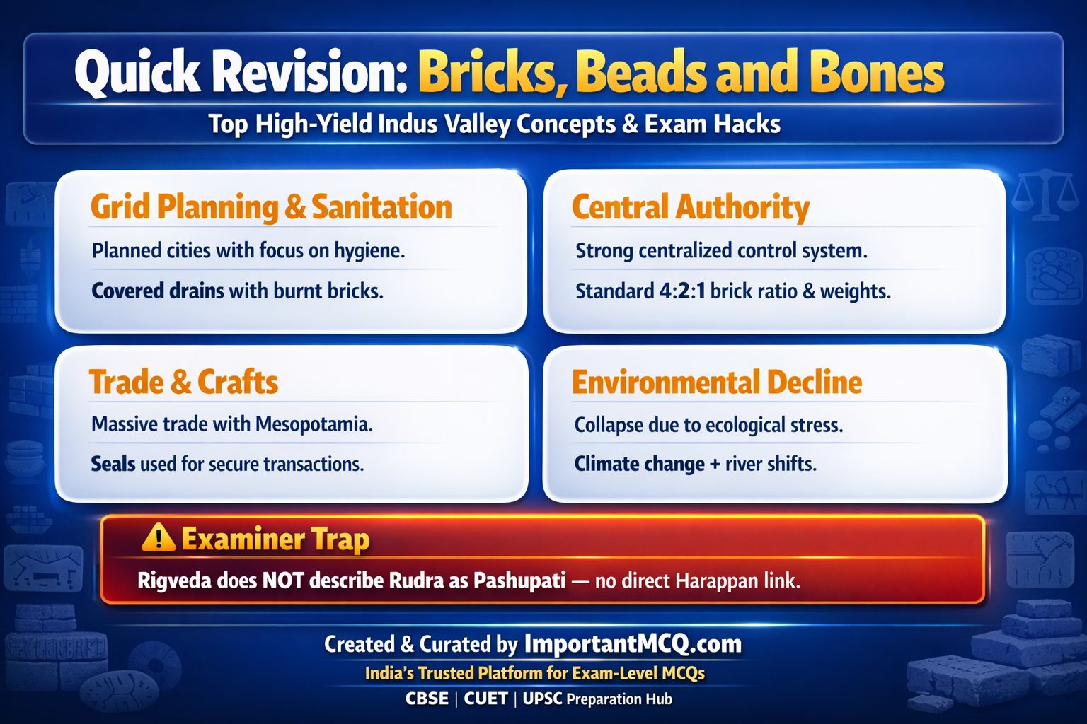
Question 38: Consider the following statements regarding the Proto-Shiva seal and its textual contradictions: 1. A famous Harappan seal depicts a figure seated cross-legged in a yogic posture, surrounded by animals including an elephant, tiger, rhinoceros, and buffalo. 2. Early scholars, including Director-General John Marshall, identified this central figure as Proto-Shiva, an early, foundational manifestation of the major Hindu deity. 3. This identification is definitively confirmed by the ancient Rigveda, which explicitly describes the early deity Rudra as a meditating yogi holding the title of Pashupati or Lord of Animals. Which of the above statements is/are correct?
- Only 1 and 2 (Correct Answer)
- Only 2 and 3
- Only 1 and 3
- 1, 2, and 3
Explanation
Direct Answer: Option A is the correct answer because statement 3 contains a massive historical contradiction regarding the descriptions found in the Rigveda.Concept Definition: The Proto-Shiva seal is a vital artifact used to argue for the continuity of religious practices from the Harappan civilization into later Vedic and Puranic Hinduism.Structural Breakdown: The seal clearly shows a horned figure in a meditative, yogic stance, flanked by wild beasts.John Marshall combined these visual cues (the horns, the yoga posture, the animals) to declare the figure as an early version of Shiva, specifically in his aspect as Pashupati.Historical/Related Context: To verify this, historians cross-referenced the earliest known religious text of India, the Rigveda (compiled c. 1500-1000 BCE). The Rigveda mentions a prominent god named Rudra, which is a name later used for Shiva in Puranic Hinduism.Causal Reasoning: Statement 3 is entirely false and represents the primary flaw in Marshall’s theory.While the Rigveda does mention Rudra, it does not depict Rudra as Pashupati (Lord of Animals), nor does it describe him as a meditating yogi.Because the earliest textual description of Rudra completely contradicts the visual imagery on the seal, many modern historians argue that the figure cannot be a “Proto-Shiva,” and might instead represent an ancient, pre-Vedic shamanic deity.
Question 39: Consider the following statements regarding the archaeological evidence of animism and religious structures in the Harappan civilization: 1. Certain Harappan seals depict elaborate religious scenes featuring rituals being performed in front of tree spirits, specifically indicating the veneration of the peepal tree. 2. Numerous conical stone objects found across various Harappan sites have been classified by archaeologists as lingas, indicating the presence of early phallic worship. 3. To house these sacred tree spirits and stone lingas, the Harappans constructed massive, monumental stone temples structurally identical to the Ziggurats of Mesopotamia. Which of the above statements is/are correct?
- Only 1 and 2 (Correct Answer)
- Only 2 and 3
- Only 1 and 3
- 1, 2, and 3
Explanation
Direct Answer: Option A is the correct answer because statement 3 is factually false regarding the existence of monumental temples in the Harappan civilization.Concept Definition: Harappan religious practices appear to have been deeply tied to nature worship and ritual purity, relying heavily on animism rather than centralized, institutionalized temple worship.Structural Breakdown: The visual evidence on seals strongly points to nature veneration, with clear depictions of the peepal tree.Additionally, the discovery of polished, conical stone baetyls strongly suggests that the worship of the linga (a symbol later associated with Shiva) had its roots in the Harappan era.Historical/Related Context: In contemporary Mesopotamia and Egypt, religion was deeply institutionalized, centered around massive stone or mud-brick structures (Ziggurats and Temple Complexes) that dominated the urban landscape and economy.Causal Reasoning: Statement 3 is a complete archaeological fallacy.Despite over a century of extensive excavation at major sites like Harappa, Mohenjodaro, and Dholavira, archaeologists have never found a single structure that can be definitively identified as a temple or a palace.Harappan worship appears to have been a decentralized, possibly domestic or open-air practice, starkly differentiating them from their temple-building contemporaries in the Near East.
Question 40: Consider the following statements regarding the competing historical theories on Harappan political authority: 1. One archaeological theory suggests that the Harappan society had no absolute rulers, and that everybody in the civilization enjoyed a perfectly equal social status. 2. A second theory posits that there was no single centralized state, but rather several independent rulers governing different urban centers like Mohenjodaro, Harappa, and Dholavira. 3. The third theory, which argues for a single centralized state, is supported by the extreme standardization of bricks across the civilization and the strategic establishment of settlements near raw materials. Which of the above statements is/are correct?
- Only 1 and 2
- Only 2 and 3
- Only 1 and 3
- 1, 2, and 3 (Correct Answer)
Explanation
Direct Answer: Option D is the correct answer, as all three statements accurately reflect the primary competing theories among historians regarding Harappan governance.Concept Definition: Because there are no deciphered royal decrees or massive palace structures to definitively prove who ruled the Indus Valley, archaeologists must rely on theoretical frameworks based on the distribution of physical artifacts.Structural Breakdown: The academic debate is split into three camps.Theory 1: A completely egalitarian society with no rulers (highly unlikely given the complex urban planning). Theory 2: A decentralized system of allied city-states, where Mohenjodaro and Harappa had their own separate kings.Theory 3: A massive, unified empire controlled by a single, powerful state authority.Historical/Related Context: The sheer geographical scale of the Harappan civilization makes the concept of a single ruler staggering, yet the physical evidence heavily leans in that direction.Causal Reasoning: The third theory is currently considered the most plausible by many leading archaeologists.The reasoning is based on logistics: the standardization of the 4:2:1 brick ratio from the Himalayas to Gujarat, the uniform weight system, and the coordinated mass-mobilization of labor required to build platforms and massive drainage systems strongly indicate that a single, uncompromising central authority dictated municipal standards across the entire civilization.
Question 41: Consider the following statements regarding the chronology and geographical shifting of the Late Harappan phase: 1. By approximately 1900 BCE, archaeological evidence indicates that most mature Harappan sites in regions such as Cholistan had been completely abandoned. 2. Coinciding with this abandonment, there was a noticeable expansion of population and new settlements eastward and southward into Gujarat, Haryana, and western Uttar Pradesh. 3. The material culture of this newly settled post-urban phase remained identical to the mature phase, retaining the widespread use of standardized weights, seals, and specialized beads. Which of the above statements is/are correct?
- Only 1 and 2 (Correct Answer)
- Only 2 and 3
- Only 1 and 3
- 1, 2, and 3
Explanation
Direct Answer: Option A is the correct answer because statement 3 is factually incorrect regarding the material culture of the Late Harappan phase.Concept Definition: The decline of the Harappan civilization was not a sudden disappearance of people, but rather a “de-urbanization” or transformation into what archaeologists call the Late Harappan or successor cultures.Structural Breakdown: The timeline is clear: around 1900 BCE, the core mature regions began to empty out.The population did not vanish; they migrated, causing an expansion of rural settlements in peripheral zones like Gujarat and western UP. Historical/Related Context: This transitional period is sometimes referred to as the Localization Era.The massive, interconnected trade networks collapsed, forcing people to rely on localized, rural subsistence farming rather than urban craft production.Causal Reasoning: Statement 3 is entirely false.The defining characteristic of the Late Harappan phase is the “disappearance of the distinctive artifacts of the civilization.” Standardized chert weights, steatite seals, specialized lapis lazuli beads, and even writing completely vanished, reflecting the total collapse of the complex urban economy that previously demanded these administrative and luxury tools.
Question 42: Consider the following statements regarding the environmental and climatic theories surrounding the Harappan decline: 1. Archaeological and palaeobotanical research strongly indicates that severe climate change, specifically a shift towards increased aridity, contributed significantly to the agricultural decline. 2. Extensive environmental evidence points to massive, civilization-wide deforestation, likely driven by the relentless need to harvest wood for baking millions of standardized structural bricks. 3. The drying up or shifting of major river systems, particularly the Ghaggar-Hakra system, effectively crippled the agricultural and settlement networks in regions like Cholistan. Which of the above statements is/are correct?
- Only 1 and 2
- Only 2 and 3
- Only 1 and 3
- 1, 2, and 3 (Correct Answer)
Explanation
Direct Answer: Option D is the correct answer, as all three statements accurately reflect the prevailing environmental theories regarding the civilization’s collapse.Concept Definition: Modern archaeology rejects the idea of a single, sudden catastrophe.Instead, the collapse is attributed to a complex matrix of long-term environmental degradation and climatic shifts that slowly destroyed the civilization’s agricultural foundation.Structural Breakdown: The environmental collapse had three primary vectors: climate change (decreased monsoon rainfall leading to aridity), anthropogenic degradation (deforestation), and hydrological shifts (rivers drying up or changing course). Historical/Related Context: The Ghaggar-Hakra river system, often identified with the mythological Saraswati river, was once heavily populated with mature Harappan sites.As tectonic or climatic changes choked off its water supply, these settlements became entirely unviable.Causal Reasoning: The Harappan urban model was incredibly resource-intensive.The need to bake millions of bricks for civic infrastructure required massive amounts of timber for fuel.Over centuries, this relentless deforestation, combined with a naturally drying climate and shifting rivers, completely exhausted the local carrying capacity of the land, forcing the population to abandon the mega-cities.
Question 43: Consider the following statements regarding the role of tectonic disturbances and floods in the decline of specific Harappan cities: 1. Geological surveys suggest that major tectonic disturbances or earthquakes occurred in the region, which may have severely altered the floodplain or changed the course of the Indus River. 2. Excavations at Mohenjodaro reveal that the city was completely abandoned and never re-occupied after suffering its very first catastrophic flood event. 3. The tectonic uplift is theorized to have caused a massive pooling or damming of river water, which effectively drowned several mature Harappan settlements over extended periods. Which of the above statements is/are correct?
- Only 1 and 2
- Only 1 and 3 (Correct Answer)
- Only 2 and 3
- 1, 2, and 3
Explanation
Direct Answer: Option B is the correct answer because statement 2 is factually incorrect regarding the resilience of Mohenjodaro to flooding.Concept Definition: While systemic environmental changes weakened the entire civilization, sudden geological events like tectonic uplift and severe localized flooding played a major role in destroying specific urban centers.Structural Breakdown: The Indus Valley sits near an active fault line.Evidence suggests that tectonic uplift created natural dams across the Indus River.This prevented the river from flowing to the sea, causing massive lakes to form which flooded the surrounding cities.Historical/Related Context: When the natural dams eventually broke, the catastrophic release of water would have scoured the landscape, further destroying agricultural fields and infrastructure.Causal Reasoning: Statement 2 is entirely false because the Harappans were master engineers who demonstrated incredible resilience.Stratigraphic excavations at Mohenjodaro reveal multiple, distinct layers of silt, proving that the city was flooded and painstakingly rebuilt by its inhabitants at least seven different times before it was finally abandoned during the ultimate decline of the civilization.
Question 44: Consider the following statements regarding the Aryan Invasion Theory and its subsequent debunking by modern archaeology: 1. In 1947, archaeologist R.E.M. Wheeler proposed that a violent massacre by invading Aryans caused the collapse, basing his theory on unburied skeletons found in a late phase at Mohenjodaro. 2. Wheeler correlated his archaeological findings with the ancient Rigveda, which frequently mentions the deity Indra functioning as Purandara, meaning the destroyer of forts. 3. George Dales later confirmed Wheeler’s theory in 1964 by discovering massive caches of foreign, iron-based weapons scattered across the Citadel of Mohenjodaro. Which of the above statements is/are correct?
- Only 1 and 2 (Correct Answer)
- Only 2 and 3
- Only 1 and 3
- 1, 2, and 3
Explanation
Direct Answer: Option A is the correct answer because statement 3 is a historical fallacy; George Dales actually debunked the invasion theory, not confirmed it.Concept Definition: The Aryan Invasion Theory was an early, highly sensationalized hypothesis attempting to explain the end of the Indus Valley civilization through a sudden, violent external conquest.Structural Breakdown: R.E.M. Wheeler found groups of skeletons lying in the streets of Mohenjodaro.Combining this with the Rigvedic descriptions of Indra destroying enemy forts (puras), Wheeler famously declared, “Indra stands accused” of the Harappan destruction.Historical/Related Context: In 1964, archaeologist George Dales critically re-examined Wheeler’s evidence in an essay titled “The Mythical Massacre at Mohenjodaro.” Dales pointed out massive flaws in the stratigraphic analysis.Causal Reasoning: Statement 3 is completely false.Dales definitively debunked the invasion theory.He proved that the skeletons were found in completely different stratigraphic layers, meaning these people died hundreds of years apart, not in a single violent event.Furthermore, absolutely no extensive burning, armor, or foreign weapons were found in the final occupational levels to suggest a battle or a siege.
Question 45: Consider the following statements regarding the collapse of Harappan central authority and the end of urbanization: 1. The ultimate hallmark of the Harappan collapse was the sudden and complete disappearance of a strong, unifying central political or administrative authority. 2. Following the collapse of the cities, the Harappan script was preserved by local priests and eventually evolved directly into the Brahmi script used by the Mauryan Empire. 3. During the Late Harappan phase, the highly standardized 4:2:1 brick ratio was largely abandoned, and the construction of massive public buildings and grid-pattern streets completely ceased. Which of the above statements is/are correct?
- Only 1 and 2
- Only 1 and 3 (Correct Answer)
- Only 2 and 3
- 1, 2, and 3
Explanation
Direct Answer: Option B is the correct answer because statement 2 is factually incorrect regarding the survival and evolution of the Harappan script.Concept Definition: The end of the Harappan civilization was fundamentally the end of an overarching state structure.The unifying force that maintained strict municipal standards across hundreds of miles evaporated.Structural Breakdown: Without a central authority to enforce standards or manage long-distance trade, the markers of a unified empire vanished.The construction of complex civic amenities (drains, great baths, granaries) ceased entirely.Local, haphazard house construction replaced the strict grid planning.Historical/Related Context: The subsequent cultures that occupied the region, such as the Cemetery H culture or the Jhukar culture, were rural, localized, and lacked the massive economic surplus required to sustain urbanization.Causal Reasoning: Statement 2 is entirely false.When the state collapsed, the administrative need for writing vanished with it.The Harappan script died out completely and was lost to history.The Brahmi script, which appeared over a thousand years later during the Mauryan period, has no proven evolutionary link to the Harappan script, marking a severe, centuries-long gap in literacy on the Indian subcontinent.
Question 46: Consider the following statements regarding Alexander Cunningham and his early archaeological investigations in India: 1. Alexander Cunningham, the first Director-General of the Archaeological Survey of India, primarily relied on the accounts of Chinese Buddhist pilgrims to guide his early excavations. 2. When presented with an engraved Harappan seal by an Englishman, Cunningham successfully identified it as belonging to a civilization far older than the early historic cities of the Ganga valley. 3. Cunningham’s main chronological confusion stemmed from his rigid belief that Indian history began exclusively with the emergence of the first cities in the Ganga valley. Which of the above statements is/are correct?
- Only 1 and 2
- Only 2 and 3
- Only 1 and 3 (Correct Answer)
- 1, 2, and 3
Explanation
Direct Answer: Option C is the correct answer because statement 2 is factually incorrect regarding Cunningham’s assessment of the seal.Concept Definition: Alexander Cunningham’s tenure as the first Director-General of the ASI laid the groundwork for Indian archaeology, though his methodologies were heavily biased towards text-based historic periods.Structural Breakdown: Cunningham used the written itineraries of Chinese pilgrims (who visited between the fourth and seventh centuries CE) to locate ancient sites.When he excavated Harappa, he found artifacts but could not place them in the correct historical timeline.Historical/Related Context: Cunningham was given a Harappan seal by an Englishman named Alexander Seal.He noted the seal but unsuccessfully tried to place it within the time frame he was familiar with.Causal Reasoning: Statement 2 is false.Cunningham failed to realize the antiquity of Harappa because he, like many scholars of his time, operated under the strict paradigm that Indian history only began with the development of cities in the Ganga valley (around the 6th century BCE). Because Harappa was not part of that specific textual geography or timeline, its true significance completely eluded him.
Question 47: Consider the following statements regarding the early 20th-century discoveries that led to the identification of the Harappan civilization: 1. Archaeologist Daya Ram Sahni discovered Harappan seals at the site of Harappa in stratigraphic layers that were definitively older than Early Historic levels. 2. Shortly after, Rakhal Das Banerji found almost identical seals at Mohenjodaro, leading to the groundbreaking conjecture that these two distant sites were part of a single ancient culture. 3. Based entirely on these specific discoveries by Sahni and Banerji, Alexander Cunningham formally announced the discovery of the Indus Valley Civilization to the world in 1924. Which of the above statements is/are correct?
- Only 1 and 2 (Correct Answer)
- Only 2 and 3
- Only 1 and 3
- 1, 2, and 3
Explanation
Direct Answer: Option A is the correct answer because statement 3 incorrectly identifies the individual who announced the discovery to the world.Concept Definition: The realization that the Indus Valley harbored a previously unknown Bronze Age civilization was not a sudden event, but a cumulative process pieced together by pioneering Indian archaeologists.Structural Breakdown: The puzzle was solved by connecting artifacts from two different sites.Daya Ram Sahni’s excavations at Harappa yielded seals from deep, pre-historic layers.When Rakhal Das Banerji found identical seals at Mohenjodaro (hundreds of miles away) in 1922, it provided the definitive proof of a widespread, unified ancient culture.Historical/Related Context: This realization shattered the existing historical timelines, pushing India’s urban history back by thousands of years, making it a contemporary of ancient Mesopotamia and Egypt.Causal Reasoning: Statement 3 is false because Alexander Cunningham had already retired and passed away long before these discoveries.It was actually John Marshall, the then Director-General of the ASI, who compiled the data from Sahni and Banerji and formally announced the discovery of the new civilization to the global archaeological community in 1924.
Question 48: Consider the following statements regarding John Marshall’s tenure and his specific excavation methodology at Harappan sites: 1. John Marshall’s appointment as Director-General marked a major milestone, as he was the first professional archaeologist to work in India, bringing substantial experience from his work in Greece and Crete. 2. In 1924, John Marshall published his findings in the Illustrated London News, formally announcing the discovery of the Indus Valley civilization. 3. Marshall’s primary excavation methodology involved carefully following the natural stratigraphy of the mound, ensuring that artifacts from different historical layers were never mixed together. Which of the above statements is/are correct?
- Only 1 and 2 (Correct Answer)
- Only 2 and 3
- Only 1 and 3
- 1, 2, and 3
Explanation
Direct Answer: Option A is the correct answer because statement 3 completely misrepresents John Marshall’s flawed excavation methodology.Concept Definition: John Marshall is credited with bringing global attention to the Harappan civilization, but his field techniques severely compromised the chronological context of the artifacts he discovered.Structural Breakdown: Marshall brought professional enthusiasm and international experience to Indian archaeology.His 1924 announcement was a monumental event in world history, prompting scholars like S.N. Roy to write that Marshall left India three thousand years older than he had found her.Historical/Related Context: Despite his historical importance, Marshall’s field methods were highly destructive by modern standards.He ignored the natural undulating layers of the earth.Causal Reasoning: Statement 3 is entirely false.Marshall’s fatal flaw was that he excavated in strict, uniform horizontal lines across the mound, completely ignoring the natural stratigraphy.Because of this mechanical approach, artifacts found at the exact same physical depth but originating from entirely different cultural and temporal periods were grouped together, resulting in the permanent loss of vital chronological context for thousands of excavated items.
Question 49: Consider the following statements regarding R.E.M. Wheeler’s contributions to Harappan archaeology: 1. R.E.M. Wheeler, who took over as Director-General of the ASI in 1944, fundamentally changed excavation methods by introducing a rigid, military-like precision to the discipline. 2. Wheeler officially recognized that it was essential to follow the natural stratigraphy of the mound rather than digging mechanically along uniform horizontal lines. 3. Because of his strict military background, Wheeler strictly restricted the excavation of all Harappan sites to British military personnel, completely barring Indian archaeologists from participating. Which of the above statements is/are correct?
- Only 1 and 2 (Correct Answer)
- Only 2 and 3
- Only 1 and 3
- 1, 2, and 3
Explanation
Direct Answer: Option A is the correct answer because statement 3 is a complete historical fabrication regarding the exclusion of Indian archaeologists.Concept Definition: R.E.M. Wheeler is a central figure in the historiography of Harappan archaeology, credited with rectifying the methodological errors of his predecessors and professionalizing field techniques.Structural Breakdown: Wheeler brought his background as a British army brigadier into the archaeological trenches.He instituted rigorous discipline, precise recording, and most importantly, the method of stratigraphic digging.Historical/Related Context: Stratigraphy is the study of rock layers and layering.Wheeler understood that a mound builds up unevenly over time due to human habitation, collapse, and rebuilding.Therefore, digging straight horizontal lines across these uneven layers destroys the timeline.Causal Reasoning: Statement 3 is entirely false.Wheeler did not ban Indian archaeologists; in fact, he actively trained a whole new generation of prominent Indian archaeologists (such as B.B. Lal) at his famous Taxila field school, ensuring that indigenous scholars possessed the advanced, scientific stratigraphic techniques required to lead the ASI after India gained independence.
Question 50: Consider the following statements regarding the impact of the 1947 partition on Harappan archaeology and modern exploration: 1. The partition of the subcontinent in 1947 resulted in the vast majority of the known mature Harappan sites, including Mohenjodaro and Harappa, falling within the new borders of Pakistan. 2. This massive geographical loss spurred Indian archaeologists to conduct extensive new surveys within Indian territory, leading to the discovery of major settlements in Gujarat, Rajasthan, and Haryana. 3. Since the 1980s, international interest has completely vanished, and modern excavations at Harappan sites are strictly conducted by the ASI without any foreign collaboration or modern scientific techniques. Which of the above statements is/are correct?
- Only 1 and 2 (Correct Answer)
- Only 2 and 3
- Only 1 and 3
- 1, 2, and 3 High-Yield Core Concepts Urban Grid & Sanitation Unlike contemporary civilizations, the Harappans uniquely prioritized egalitarian public sanitation, covered street drains, and strict grid-iron street planning over massive royal monuments. Absolute Standardization A highly centralized state authority is proven by the uncompromising uniformity of the 4:2:1 brick ratio and the strict binary/decimal chert weight system across the vast empire. Logistics & Maritime Trade Harappans sustained a complex international export economy with Oman (Magan) and Mesopotamia, securing their luxury goods with tamper-evident wet clay sealings. Environmental Collapse The end of the civilization was not caused by a sudden Aryan invasion, but rather by a complex matrix of long-term climatic aridity, shifting rivers, and massive anthropogenic deforestation. Semantic Comparison: Harappan Civilization vs Mesopotamian Civilization Feature / Metric Harappan Civilization Mesopotamian Civilization Core Definition Highly standardized, egalitarian urban centers in the Indus Valley. City-states centered around monumental royal and religious architecture. Primary Use Case Focus on public sanitation, uniform weights, and standardized grid streets. Focus on massive Ziggurats, royal tombs, and complex cuneiform archives. Exam Importance Tests knowledge of town planning, trade seals, and environmental decline. Tests comparative knowledge of ancient trade networks (Meluhha vs Magan).
Explanation
Direct Answer: Option A is the correct answer because statement 3 is factually incorrect regarding the current state of international collaboration and scientific methodology.Concept Definition: The political division of 1947 drastically altered the landscape of South Asian archaeology, forcing a massive geographical pivot in where field research was conducted.Structural Breakdown: When the borders were drawn, the core Indus Valley region went to Pakistan, depriving India of the civilization’s namesake sites.To compensate, Indian archaeologists launched aggressive surveys eastward and southward, successfully uncovering hundreds of new Late and Mature Harappan sites in places like Lothal, Kalibangan, Rakhigarhi, and Dholavira.Historical/Related Context: Archaeology is a continuously evolving discipline.While the early decades focused on discovering large urban centers, modern archaeology is increasingly focused on micro-analysis, environmental data, and understanding the lives of common people.Causal Reasoning: Statement 3 is entirely false.Since the 1980s, there has been a massive surge in international interest.Specialists from all over the world routinely collaborate with Indian and Pakistani archaeologists, employing highly advanced scientific techniques such as surface exploration, paleobotany, and isotopic analysis to recover minute traces of ancient environments, diets, and trade routes.